Please use this identifier to cite or link to this item:
https://hdl.handle.net/11681/41085| Title: | Development of three-dimensional wetting and drying algorithm for the Geophysical Scale Transport Multi-Block Hydrodynamic Sediment and Water Quality Transport Modeling System (GSMB) |
| Authors: | Chapman, Raymond S. Luong, Phu V. Kim, Sung-Chan Hayter, E. J. |
| Keywords: | Wetting Drying Computer simulation Dredging Operations and Environmental Research Program (U.S.) |
| Publisher: | Engineer Research and Development Center (U.S.) |
| Series/Report no.: | Technical Note (Dredging Operations and Environmental Research Program (U.S.)) ; no. ERDC/TN DOER-D23 |
| Abstract: | The Environmental Laboratory (EL) and the Coastal and Hydraulics Laboratory (CHL) have jointly completed a number of large-scale hydrodynamic, sediment and water quality transport studies. EL and CHL have successfully executed these studies utilizing the Geophysical Scale Transport Modeling System (GSMB). The model framework of GSMB is composed of multiple process models as shown in Figure 1. Figure 1 shows that the United States Army Corps of Engineers (USACE) accepted wave, hydrodynamic, sediment and water quality transport models are directly and indirectly linked within the GSMB framework. The components of GSMB are the two-dimensional (2D) deep-water wave action model (WAM) (Komen et al. 1994, Jensen et al. 2012), data from meteorological model (MET) (e.g., Saha et al. 2010 - http://journals.ametsoc.org/doi/pdf/10.1175/2010BAMS3001.1), shallow water wave models (STWAVE) (Smith et al. 1999), Coastal Modeling System wave (CMS-WAVE) (Lin et al. 2008), the large-scale, unstructured two-dimensional Advanced Circulation (2D ADCIRC) hydrodynamic model (http://www.adcirc.org), and the regional scale models, Curvilinear Hydrodynamics in three dimensions-Multi-Block (CH3D-MB) (Luong and Chapman 2009), which is the multi-block (MB) version of Curvilinear Hydrodynamics in three-dimensions-Waterways Experiments Station (CH3D-WES) (Chapman et al. 1996, Chapman et al. 2009), MB CH3D-SEDZLJ sediment transport model (Hayter et al. 2012), and CE-QUAL Management - ICM water quality model (Bunch et al. 2003, Cerco and Cole 1994). Task 1 of the DOER project, “Modeling Transport in Wetting/Drying and Vegetated Regions,” is to implement and test three-dimensional (3D) wetting and drying (W/D) within GSMB. This technical note describes the methods and results of Task 1. The original W/D routines were restricted to a single vertical layer or depth-averaged simulations. In order to retain the required 3D or multi-layer capability of MB-CH3D, a multi-block version with variable block layers was developed (Chapman and Luong 2009). This approach requires a combination of grid decomposition, MB, and Message Passing Interface (MPI) communication (Snir et al. 1998). The MB single layer W/D has demonstrated itself as an effective tool in hyper-tide environments, such as Cook Inlet, Alaska (Hayter et al. 2012). The code modifications, implementation, and testing of a fully 3D W/D are described in the following sections of this technical note. |
| Description: | Technical Note |
| Gov't Doc #: | ERDC/TN DOER-D23 |
| Rights: | Approved for Public Release; Distribution is Unlimited |
| URI: | https://hdl.handle.net/11681/41085 http://dx.doi.org/10.21079/11681/41085 |
| Appears in Collections: | Technical Note |
Files in This Item:
| File | Description | Size | Format | |
|---|---|---|---|---|
| ERDC-TN DOER-D23.pdf | ERDC/TN DOER-D23 | 956.7 kB | Adobe PDF | 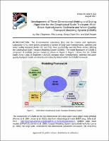 View/Open |