Please use this identifier to cite or link to this item:
https://hdl.handle.net/11681/8504Full metadata record
| DC Field | Value | Language |
|---|---|---|
| dc.contributor | United States. Army. Corps of Engineers. St. Paul District | - |
| dc.contributor | United States. Army. Corps of Engineers. Rock Island District | - |
| dc.contributor | Information Technology Laboratory (U.S.) | - |
| dc.contributor | Monitoring Completed Navigation Projects Program (U.S.) | - |
| dc.contributor.author | Abraham, David D. | - |
| dc.contributor.author | Cowan, Mark A. | - |
| dc.contributor.author | Hendrickson, Jon S. | - |
| dc.contributor.author | Katzenmeyer, William M. | - |
| dc.contributor.author | Landwehr, Kevin J. | - |
| dc.contributor.author | Pratt, Thad C. | - |
| dc.date.accessioned | 2016-06-20T13:27:22Z | - |
| dc.date.available | 2016-06-20T13:27:22Z | - |
| dc.date.issued | 2006-04 | - |
| dc.identifier.uri | http://hdl.handle.net/11681/8504 | - |
| dc.description | Technical Report | - |
| dc.description | Abstract: Construction of navigation locks and dams on the upper Mississippi River about 60 years ago submerged wing dam training structures, thereby reducing their effectiveness and increasing secondary channel and floodplain conveyance. The U.S. Army Engineer District, St. Paul, executed a drawdown of Pool 8 (upstream of Lock and Dam No. 8) near La Crosse, WI, during the summers of 2001 and 2002. Water levels were allowed to drop below normal minimum values to expose mud flats, promote seed germination, and benefit fish and wildlife. By lowering water levels during a drawdown, wing dam training structures submergence and floodplain conveyance will be decreased, and flow patterns around the training structures will be altered. This could result in sediment mobilization and scour in the navigation channel. During the spring of 2001, three closure dams were constructed in Pool 13 (upstream of Lock and Dam No.13) by the U.S. Army Engineer District, Rock Island, near Savannah, IL. These closure dams are actually submerged weirs that should allow water to continue to flow into the backwater areas of the islands of Pool 13, but at reduced rates. At issue is whether the main channel might require reduced dredging in future years as a result of the construction of the closure dams and, also, whether the backwaters of the eastern side of the islands will fill with sediment. A new and expedient methodology for the computation of bed-load transport (Integrated Section Surface Difference Over Time (ISSDOT)) was developed using multi-beam bathymetric data. The total river bed volume change with time, when multiplied by the density of the water/sediment mixture, yields a mass transport rate. Results of ISSDOT computations for Pool 8, and other analyses (sediment budget and geographic information system (GIS) analyses, and transport function analysis) of the same river region, confirm that: (A.) the observed drawdown did indeed have the effect of increasing sediment mobilization within the study reach, (B.) the original wing dam structures as designed, and in conjunction with a drawdown, positively influence sediment movement in the reach, and (C.) it will be possible to project sediment movement before, during, and after such drawdown events. By utilizing ISSDOT technology and other river management information gleaned from this monitoring study, river managers can more efficiently plan their dredging requirements for events such as the Pool 8 drawdown. For the region of interest at Pool 13, in the main channel, two areas showed short-term occurrences of scour and then redeposition that was measurable and statistically significant. However, over the entire monitoring period of November 2001 to July 2004, the net result showed no discernable change in the main channel bathymetry with regard to average depths in these two areas. A third area of the main channel showed the same scour and then deposition trend as the other two areas for the same time periods. However, over the entire monitoring period, the net result was a discernible scour trend in the main channel. For the back channel, one area showed a net deposition trend of nearly 0.15 m (0.5 ft) in that area between June 2002 and July 2004. In another area of the back channel, all measurements showed a net deposition trend with the maximum being about 0.34 m (1.1 ft) over the entire survey period of 32 months. The net deposition in the back channel is statistically significant. As in the main channel, whether the deposition in the back channel will continue cannot be determined from the present data. | - |
| dc.publisher | Coastal and Hydraulics Laboratory (U.S.) | - |
| dc.publisher | Engineer Research and Development Center (U.S.) | - |
| dc.relation | http://acwc.sdp.sirsi.net/client/en_US/search/asset/1002723 | - |
| dc.relation.ispartofseries | ERDC TR ; 06-2. | - |
| dc.rights | Approved for public release; distribution is unlimited. | - |
| dc.source | This Digital Resource was created in Microsoft Word and Adobe Acrobat | - |
| dc.subject | Closure dams | - |
| dc.subject | Drawdown | - |
| dc.subject | Sedimentation | - |
| dc.subject | Upper Mississippi River | - |
| dc.subject | Wing dams | - |
| dc.subject | Sediment transport | - |
| dc.subject | Deposition | - |
| dc.subject | Hydraulic structures | - |
| dc.subject | Navigation structures | - |
| dc.subject | Integrated Section Surface Difference Over Time | - |
| dc.subject | ISSDOT | - |
| dc.subject | Bed-load transport | - |
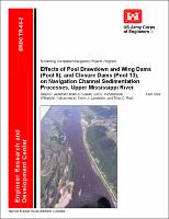
| dc.title | Effects of pool drawdown and wing dams (Pool 8), and closure dams (Pool 13), on navigation channel sedimentation processes, Upper Mississippi River | - |
| dc.type | Report | en_US |
| Appears in Collections: | Technical Report | |