Please use this identifier to cite or link to this item:
https://hdl.handle.net/11681/39002| Title: | Lower Mississippi River : Early Stream Channels at Approximate Half-Century Intervals : Cairo, Ill. to Baton Rouge, La., Mile 0 to 842 |
| Authors: | United States. Mississippi River Commission |
| Keywords: | Mississippi River--Maps River channels |
| Publisher: | United States. Mississippi River Commission. |
| Abstract: | This series of 12 maps show the historic stream channels of the Mississippi River from Cairo, Illinois to Baton Rouge, Louisiana as known from a series of surveys undertaken from the years 1765 to 1932. |
| Description: | Maps |
| Rights: | Approved for Public Release; Distribution is Unlimited |
| URI: | https://hdl.handle.net/11681/39002 |
| Appears in Collections: | Maps |
Files in This Item:
| File | Description | Size | Format | |
|---|---|---|---|---|
| MS River Early Stream Channel Maps 1938.pdf | 17.07 MB | Adobe PDF | 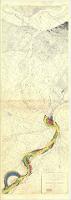 View/Open |