Please use this identifier to cite or link to this item:
https://hdl.handle.net/11681/3860| Title: | Using high-resolution, regional-scale data to characterize floating aquatic nuisance vegetation in Coastal Louisiana |
| Authors: | Allen, Yvonne C. Suir, Glenn M. |
| Keywords: | Aquatic vegetation Aquatic environments Aquatic nuisance vegetation Coastal Louisiana Waterways Management Monitoring GIS Remote sensing Aquatic Plant Control Research Program (U.S.) |
| Publisher: | Engineer Research and Development Center (U.S.) |
| Series/Report no.: | Technical Note (Aquatic Plant Control Research Program (U.S.)) ; no.ERDC/TN APCRP-EA-27 |
| Abstract: | Introduction: Traditionally, the US Army Corps of Engineers (USACE) New Orleans District (MVN) has relied on a team of three highly trained field personnel to monitor and determine the appropriate location and treatment frequency for floating nuisance aquatic vegetation (AV) within their area of responsibility (AOR) in coastal Louisiana (Figure 1). Recently, the MVN has experienced a reduction in funding under the Removal of Aquatic Growth (RAG) Program. As a result of decreased funding, infestations have not been routinely monitored and normal control operations have not been performed. While concern about infestations is increasing, assessment and management remain insufficient, resulting in a high potential for impeded navigation on waterways in the district. In the absence of an active RAG program, the USACE Engineer Research and Development Center (in coordination with MVN) investigated the effectiveness of remote sensing to evaluate and track the growth of nuisance aquatic vegetation. Previous studies have demonstrated the ability of multi-spectral imagery and remote sensing techniques to identify and quantify seasonal and yearly changes in aquatic vegetation type and distribution in inland waters with suitable field data for image calibration (Jensen et al. 1992, Steeves et al. 1999). These remote sensing methods are increasingly important to RAG programs because they: (1) reduce the time and resources required for mapping aquatic plant infestations in navigable waterways and identify potential threats to water management structures, which facilitates more frequent updates of potentially rapidly changing conditions; (2) provide presence/absence information that is critical for the planning, monitoring, and effectiveness of vegetation removal efforts (Jakubauskas et al. 2002); and (3) provide capabilities for predicting future aquatic plant infestations and identifying areas of concern. The objective of this study was to develop an innovative capability to regularly and rapidly generate high-resolution, regional-scale mapping products that characterize the presence of floating aquatic nuisance vegetation in USACE district navigation channels. This will enhance the district’s effectiveness and efficiency in removal of aquatic plant growth. This project used and evaluated several remote sensing platforms to determine the optimal combination of spatial and spectral resolution that may be used to achieve the goals of a traditional RAG monitoring program. |
| Description: | Technical Note |
| Gov't Doc #: | ERDC/TN APCRP-EA-27 |
| Rights: | Approved for public release; distribution is unlimited |
| URI: | http://hdl.handle.net/11681/3860 |
| Appears in Collections: | Technical Note |
Files in This Item:
| File | Description | Size | Format | |
|---|---|---|---|---|
| ERDC-TN-APCRP-EA-27.pdf | ERDC/TN APCRP-EA-27 | 29.47 MB | Adobe PDF | 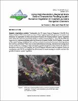 View/Open |