Please use this identifier to cite or link to this item:
https://hdl.handle.net/11681/2602Full metadata record
| DC Field | Value | Language |
|---|---|---|
| dc.contributor.author | White, Kathleen D. | - |
| dc.date.accessioned | 2016-03-14T17:44:15Z | - |
| dc.date.available | 2016-03-14T17:44:15Z | - |
| dc.date.issued | 2004-06 | - |
| dc.identifier.govdoc | ERDC/CRREL TN-04-3 | - |
| dc.identifier.uri | http://hdl.handle.net/11681/2602 | - |
| dc.description | Technical Note | - |
| dc.description.abstract | Some knowledge of ice thickness is required for the design of structures—such as bridges, dams, weirs, locks, piers, intakes, channel stabilization measures, and coastal shoreline protection— in ice-affected rivers. One recent case illustrating the need for considering ice in the design of riverine structures is the failure of the McKeesport (Pennsylvania) Marina on the Youghiogheny River in January 2001 (Fig. 1 [Silver and Fuoco 2001] and 2). The marina was constructed in 1997 at a cost of more than $2 million. According to the ERDC-CRREL Ice Jam Database sources (National Weather Service 2001a, b; Veltri 2001), ice jam breakup, jamming, and failure resulted in the complete destruction of the marina by chunks of ice measuring up to one foot thick. Contemporary reports estimated that the damage began around 6:30 p.m. on 31 January, and by 8:37 p.m., the marina was torn away. Reconstruction costs for the marina have been estimated at more than $1 million. Ice covers and ice jams can cause rapid increases in stage that can cause flooding and damage (Fig. 3). Numerical models of rivers to develop stage-frequency information required for modeling ice jams for flood damage reduction measures, flood insurance studies, and changes to the ice regime that occur from development in the floodplain or dam removal also require that ice thickness be estimated. Analyses of ice-induced scour and erosion in ice-affected rivers must include knowledge of ice thickness. Unlike discharge or stage measurements, observations of ice thickness can be challenging to locate. The USGS does record ice thickness as part of its winter discharge measurements, but these records are often archived in paper form and can be difficult to access. Some local flood warning systems measure ice thickness. A good example is the Nebraska Ice Warning System (http://dnrdata.dnr.state.ne.us/Icejam/index.asp), which contains seasonal ice thickness measurements. Given the lack of existing data, ice thickness must often be estimated. Because ice covers result from complex physical processes, there is not yet a method to account for all factors affecting thickness. This technical note presents a method to estimate ice thickness that results from heat transfer processes based on meteorological data. | - |
| dc.format.extent | 6 pages/281.8 Kb | - |
| dc.publisher | Cold Regions Research Engineering Laboratory (U.S.) | - |
| dc.publisher | Engineer Research and Development Center (U.S.) | - |
| dc.relation | http://acwc.sdp.sirsi.net/client/en_US/search/asset/1001540 | - |
| dc.relation.ispartofseries | ERDC/CRREL ; TN-04-3 | - |
| dc.rights | Approved for Public Release; Distribution is Unlimited. | - |
| dc.source | This Digital Resource was created in Microsoft Word and Adobe Acrobat. | - |
| dc.subject | Ice on rivers, lakes, etc | - |
| dc.subject | River ice thickness | - |
| dc.subject | Ice jams | - |
| dc.title | Ice engineering : method to estimate river ice thickness based on meteorological data | - |
| dc.type | Report | - |
| Appears in Collections: | Technical Note | |
Files in This Item:
| File | Description | Size | Format | |
|---|---|---|---|---|
| ERDC--CRREL-TN-04-3.pdf | 281.82 kB | Adobe PDF | 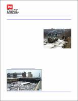 View/Open |