Please use this identifier to cite or link to this item:
https://hdl.handle.net/11681/25784Full metadata record
| DC Field | Value | Language |
|---|---|---|
| dc.contributor.author | United States. Beach Erosion Board | - |
| dc.contributor.author | Engineer Research and Development Center (U.S.) | - |
| dc.contributor.author | Coastal and Hydraulics Laboratory (U.S.) | - |
| dc.contributor.author | Coastal Engineering Research Center (U.S.) | - |
| dc.date.accessioned | 2017-12-05T20:54:39Z | - |
| dc.date.available | 2017-12-05T20:54:39Z | - |
| dc.date.issued | 1989-11-10 | - |
| dc.identifier.uri | http://hdl.handle.net/11681/25784 | - |
| dc.description | Aerial photograph taken of the southern coast of Murrell's Inlet, South Carolina. Photo is the forty-eighth image in a series of 62 photographs. Photograph was taken on Kodak Safety Film on November 10, 1989. Image scale: 1"=400'. Geospatial Reference: North 33.493467, South 33.476676, East -79.072071, West -79.091918 | en_US |
| dc.description.abstract | Aerial photograph of Murrell's Inlet, South Carolina from November 10, 1989 | en_US |
| dc.language.iso | en_US | en_US |
| dc.publisher | Engineer Research and Development Center (U.S.) | en_US |
| dc.relation.ispartofseries | Aerial Photographs (Murrell's Inlet, NOV 1989);1-48 | - |
| dc.rights | Approved for public release; distribution is unlimited. | - |
| dc.subject | Beach erosion--South Carolina | en_US |
| dc.subject | Beach erosion | en_US |
| dc.subject | Coastal Engineering Research Center (U.S.) | en_US |
| dc.subject | Aerial photography | en_US |
| dc.subject | Murrells Inlet (S.C.)--Maps | en_US |
| dc.subject | Murrells Inlet Region (S.C.)--History | en_US |
| dc.title | 1-48 - Murrell's Inlet, South Carolina NOV 1989 (Aerial Photographs) | en_US |
| dc.type | Image | en_US |
| Appears in Collections: | Photograph | |
Files in This Item:
| File | Description | Size | Format | |
|---|---|---|---|---|
| MI_NOV 1989_1-48.tif | Murrell's Inlet 1989, Photo 1-48 | 103.83 MB | TIFF | 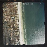 View/Open |