Please use this identifier to cite or link to this item:
https://hdl.handle.net/11681/25773| Title: | 2-3 - Murrell's Inlet, South Carolina NOV 1989 (Aerial Photographs) |
| Authors: | United States. Beach Erosion Board Engineer Research and Development Center (U.S.) Coastal and Hydraulics Laboratory (U.S.) Coastal Engineering Research Center (U.S.) |
| Keywords: | Beach erosion Beach erosion--South Carolina Aerial photography Coastal Engineering Research Center (U.S.) Murrells Inlet Region (S.C.)--History Murrells Inlet (S.C.)--Maps |
| Publisher: | Engineer Research and Development Center (U.S.) |
| Series/Report no.: | Aerial Photographs (Murrell's Inlet, NOV 1989);2-3 |
| Abstract: | Aerial photograph of Murrell's Inlet, South Carolina from November 10, 1989 |
| Description: | Aerial photograph taken of the northern coast of Murrell's Inlet, South Carolina. Photo is the third image in a series of 9 photographs. Photograph was taken on Kodak Safety Film on November 10, 1989. Image scale: 1"=400'. Geospatial Reference: North 33.543153, South 33.527978, East -79.016185, West -79.032604 |
| Rights: | Approved for public release; distribution is unlimited. |
| URI: | http://hdl.handle.net/11681/25773 |
| Appears in Collections: | Photograph |
Files in This Item:
| File | Description | Size | Format | |
|---|---|---|---|---|
| MI_NOV 1989_2-3.tif | Murrell's Inlet 1989, Photo 2-3 | 103.34 MB | TIFF | 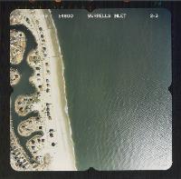 View/Open |