Please use this identifier to cite or link to this item:
https://hdl.handle.net/11681/2289Full metadata record
| DC Field | Value | Language |
|---|---|---|
| dc.contributor.author | Coastal Engineering Research Center (U.S.) | - |
| dc.date.accessioned | 2016-03-11T19:02:01Z | - |
| dc.date.available | 2016-03-11T19:02:01Z | - |
| dc.date.issued | 1981-01 | - |
| dc.identifier.uri | http://hdl.handle.net/11681/2289 | - |
| dc.description | Technical note | - |
| dc.description | Purpose: To emphasize the need for: (a) planning the layout and frequency of beach surveys, (b) positioning permanent and temporary survey markers, and (c) using accurate surveying techniques. | - |
| dc.publisher | Coastal Engineering Research Center (U.S.) | - |
| dc.publisher | Engineer Research and Development Center (U.S.) | - |
| dc.relation | http://acwc.sdp.sirsi.net/client/en_US/search/asset/1000314 | - |
| dc.relation.ispartofseries | Coastal engineering technical note ; CETN-VI-5. | - |
| dc.rights | Approved for public release; distribution is unlimited. | - |
| dc.source | This Digital Resource was created from scans of the Print Resource. | - |
| dc.subject | Beach | - |
| dc.subject | Surveys | - |
| dc.subject | Surveying techniques | - |
| dc.subject | Survey markers | - |
| dc.subject | Cape Cod | - |
| dc.subject | Dune topography | - |
| dc.subject | Erosion | - |
| dc.subject | Shorelines | - |
| dc.title | Guidelines for planning beach surveys | - |
| dc.type | Report | en_US |
| Appears in Collections: | Technical Note | |
Files in This Item:
| File | Description | Size | Format | |
|---|---|---|---|---|
| CETN-VI-5.pdf | 273.5 kB | Adobe PDF | 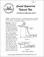 View/Open |